
If there's a question that isn't covered here and you like to find out more, please email us at adaptivescilly@scilly.gov.uk.
Why is the boardwalk necessary?
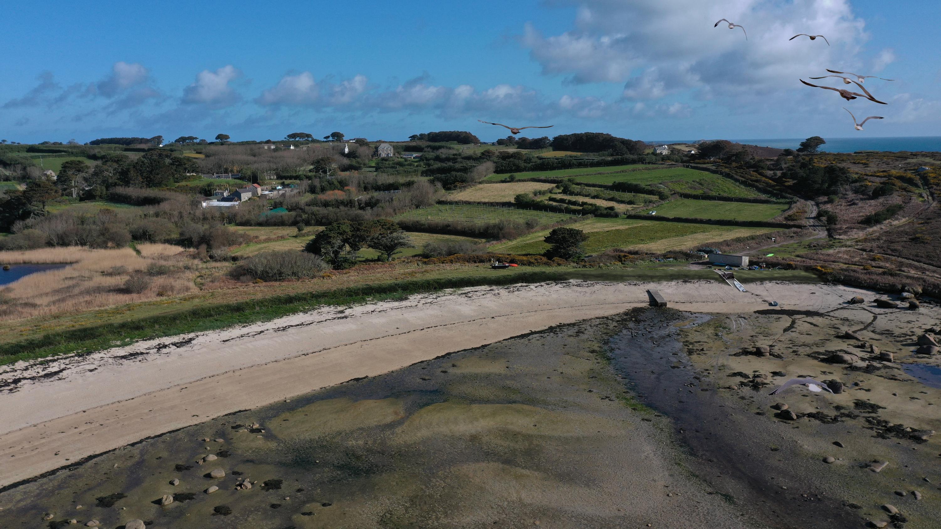
The boardwalk at the western end of the beach is necessary to prevent the dune being further eroded by the passage of feet and hooves. This erosion has created a gap in the dunes through which seawater can flow into the Higher Moors Pool during storms.
Will the design of the boardwalk will make it harder for people to access the beach, because of potential trip hazards?
The access track at the western end of the beach is already eroding, so a boardwalk will help stop this getting worse. The boardwalk will be designed and constructed to avoid trip hazards and there will be no steps on the boardwalk. We’ll have a look at the materials to be used to make sure it is appropriate for horses as well as people. The boardwalk will be generally 100 mm off the ground, graded to ground level at each end, so sand should not cover it.
The boardwalk could cause a problem for horses for several reasons. The noise from walking on it, the flexible structure will be unnerving, catching a hoof on gaps between the slats and stepping onto, and from, the boardwalk could cause problems. Damage to the boardwalk from horses could easily happen and there is a safety concern if horse riders are not able to clearly see over the bank if other users are on the boardwalk before making a crossing.
The boardwalk is designed to protect the sand from foot erosion, to prevent this offering a ‘weak point’ in the dune system, which could allow storm surge to overtop the dunes into the Higher Moors. The boardwalk will be designed to cope with storms, but if it is affected, it will be maintained. The materials will be chosen to suit use by horses, wheelchairs and pedestrians. The British Horse Society provide guidance on surfaces – including for boardwalks – which will be used to guide material choice, material strength and boardwalk width. Separate discussions will continue with the community about alternatives for horse access. The boardwalk approach is the best choice to allow the dune to move – the boardwalk can be shifted if it does so. Boardwalks have been tried and tested in many other dune situations.
Are we sure that the designs for the boardwalk can withstand a storm? Are there any alternatives to a boardwalk?
The boardwalk will be designed to cope with storms, but if it is affected, it will be maintained. The boardwalk approach is the best choice to allow the dune to move – the boardwalk can be shifted if it does so, while protecting the sand from foot erosion. Boardwalks have been tried and tested in many other dune situations.
Won’t the ramp just be a concrete eyesore?
The beach access ramp will be profiled so that it is in line with the surrounding dunes, which will be raised to provide protection against water overtopping at this end of the beach during storms. The concrete block mattress forming the surface of the access ramp will be filled with topsoil and seeded with grass. We may need to change this approach if materials are needed to be more suited for horses.
What purpose will the slip at the eastern end provide? What happens as the sides of the slip? Won’t this encourage water to flow over it and into this corner of Porth Hellick?
The ‘slip’ is a beach access ramp for maintenance of the leat outlet and to provide access for pedestrians, horses and vehicles at this end of the beach. It will be about 0.8 m above existing ground level at its crest. Because the ramp is covered with open concrete blocks filled with gravel underneath and soil on top, water running onto the ramp will percolate through. At the sides of the slip the new dune (also 0.8 m above existing ground level next to the ramp) will have the same cross-sectional profile as the ramp.
Won’t the access ramp just funnel sea water up and over when there’s a storm?
The access ramp and dune won’t focus waves over the top because they’re all at the same angle and level with respect to each other. The dune/access ramp will provide additional height to reduce the number of waves able to flow into the leat.
It’s proposed that the beach access ramp will be made from Dycel blocks and then infilled. Is there a risk that this topsoil will be washed during a storm event exposing the block work?
If the soil is washed out during a storm, it will be replaced.
How deep is the beachside anchor beam for the access ramp being buried?
There will be a minimum of 400 mm of beach cover above the concrete anchor beam.
Why can’t we just use storm boards at the existing access point instead of building a ramp?
Building the extension to the dune standing replicates a natural process, which is more in keeping with the natural environment at Porth Hellick. The construction approach for the dune will resist the ramp being exposed and left ‘proud’ by storms. Storm boards also require someone to be available to attend to them during storm events, which may not be feasible in a severe storm at Porth Hellick. A dune is a passive measure requiring less ongoing intervention.
On page 28 of the ‘Site Information’ document from the planning application it states: ‘It is agreed that the beach access ramp will not be designed to accommodate the launching of boats”, and in the ‘Design Statement Redacted’ planning document it states ‘It is understood that the client has in discussions with Duchy and it no longer the intention of Duchy that boats will be launched from the beach.” Will the access ramp be able to handle boats being towed over it and will the Duchy continue to allow boat users to launch at Porth Hellick?
Despite what it says in the design documents, the ramp will be strong enough to allow boat trailers to pass over it. The boats can be launched once a vehicle has driven over the ramp onto the beach.
How high will the new dune be above its existing level? And how long?
The new dune will be about 0.6 m above existing ground level at the boatshed, about 0.9 m above existing ground level over the leat and about 0.8 m above existing ground level at its western end. The crest of the new dune is about 50 m long and its total footprint is about 75 m long.
Will raising the dune at the east end of the bay cause more erosion to the undefended area adjacent to it?
The sea will not typically affect the dune and it will only infrequently be touched by waves. Sand beaches and dunes are ‘soft’ coastlines, which absorb wave energy as the waves move the sand around. The dunes will not cause additional erosion at the undefended area adjacent to it.
The fascicularia and hottentot fig have stabilised the system very effectively and prove a serious obstacle to overtopping but they are invasive - is there a chance that thrift, camomile and other local 'native' species could be re-established?
We would like to use non-invasive local plant species as much as we can, but whatever we use needs good dune-binding properties. Natural England are requesting that the restored sand dune sections are planted with native species, rather than the non-native Fascicularia bicolor. However, if this approach does not perform well, then we will use alternative vegetation.
Will there still be a footpath behind the beach?
Yes, it will remain.
What work will be carried out on the beachside of the dune? What impact will this have on the existing vegetation and nesting site for the ringed plovers?
The beach will be accessed only to place the materials for the access ramp. We will require the contractor to work as much as possible from behind the dunes. The existing vegetation will be removed where we’re putting the new dune/embankment and walkway in place – this is mostly grass, but occasional shrubs. The nesting site that was marked off this year will not be approached. We’re working outside nesting season, so there should be no impact from machinery noise/movement etc.
What are the construction dates?
The current plan is that work will begin in early January 2022 and be completed in early March 2022.
What contingencies are in place if the construction is delayed beyond March?
Construction can be deferred until autumn 2022.
Who will own and maintain the works once they are completed?
This is being discussed with the Duchy of Cornwall at present.
If the plans don’t get through will the project lose its funding for Porth Hellick?
Yes, the funding stops at the end of June 23 and won’t be available again. We have to do this in the 21-22 year because it takes time to organise design, planning, contracting, construction.
Is this water question as important now we have desalination on St Mary's or should we protect what we have?
We’re protecting the freshwater at Higher Moors partly because we have limited fresh groundwater available for our water supply. If the Higher Moors Pool and neighbouring local groundwater get saltier, we may have to rely on the desalination plant more. Water from the desalination plant isn’t as tasty as groundwater, and it’s much more expensive to supply. We’re also protecting the freshwater at Higher Moors because it supports a mostly freshwater ecosystem. If the Pool gets saltier, the ecosystem will be affected.
Will it be possible to access the shed on the east side and the beach during construction and late March?
Access to the shed will be allowed during the construction period. The Contractor should facilitate convenient and safe access to it when it is practicable to do so. Work is due to be completed by early March so the constraints here should be limited. However, work on the access ramp could be scheduled first to reduce the risk if the construction time slips.
Are there geological as well as ornithological and botanical (and other) issues here? Are all these issues sufficiently safeguarded?
The Environmental Statement has identified no designated or non-designated sites for geological matters within the working area. We’re aware of Camel Rock as a significant geological feature, but no works will occur near to it. The sand to be used for dune renourishment will be similar in size and composition to existing sand at Porth Hellick.
Where is the sand which matches the existing material coming from?
We’ll use Cornish granite sand, unless we can source local Scilly granite sand.
How are the services (sewage, electricity) for the forward working area going to be managed?
The contractor, when appointed, will be responsible for making arrangements for all services, including power, water and telecommunications. If there no connection to a public sewer is available, the contractor will be responsible for safely disposing of any waste generated.
Shouldn’t the EIA be updated to include information about the plovers and eels, and also include more up to date images that are reflective of the current condition of the site?
The works will not take place when plovers are nesting. The works do not affect the leat or the leat discharge pipe, so neither plovers nor eels are expected to be affected by the works.
Has the project considered the impact of extra traffic, including damage to access track?
Yes. The impact of extra traffic was assessed in the EIA. The access track will be improved with gravel to avoid damage to it.
Will the construction impact the new plover nesting site and the eels that require access into the leat?
The works will not take place when plovers are nesting. The works do not affect the leat or the leat discharge pipe, so neither plovers nor eels are expected to be affected by the works.
Will this work include improving the leat?
The maintenance of the leat discharge point and the freshwater leat will be discussed with the land managers. The aim of this project is to prevent major storms sending large volumes of water into the Higher Moors Pool all at once.
Who is maintaining the leat and outflow pipe?
The leat and outflow pipe are the property of the Duchy of Cornwall.
Could a return valve be installed in the pipe to reduce saline intrusion? Or could boards also be used?
Potentially, although it’s not part of this project.
With the amount of peat and soil that gets washed from the Downs in the winter months, is there a risk of this being forced into the leat due to the proposed track improvements?
The access track to the site that is muddy in wetter months will be protected with geotextile and overlaid with gravel at weak points to reduce the volume of silt being washed from the path. This approach also prevents silt arriving at the path from other sources (outside the path) progressing any further, by acting as a giant filter.
With the large amount of materials being transported to the site, what improvements are being made to the access track over the Downs? Will drainage be considered to prevent the track becoming waterlogged?
To improve access from Spray View and to prevent additional erosion, the worst parts of the track will be filled with geotextile and gravel. We aren’t currently planning to install drainage pipes, but the presence of gravel will prevent water flowing down the track.
The track down from Spray View is only getting worse. Are there plans to encourage fewer vehicles to use this route to the beach?
This falls outside the scope of this project.
There are other places around the bay, such as the old sea wall under the westerly face of Dick’s Carn, that would benefit of a survey and potentially improvement. Have these been looked at and could they be included as part of the work?
This extra work is not currently part of this project.